


Tel Aviv, Israel
32°04'N / 34°47'E
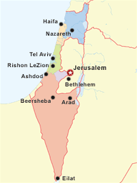
Tel Aviv is located on Israel's central-west coast of the Mediterranean Sea, approximately 55 kilometers (35 mi) northwest of Jerusalem.
Tel Aviv is accessible by road, train, sea, and air. Its major airport is Ben Gurion International (IATA: TLV), 15 kilometers (9 mi) southeast of the city.
Notes:
- Air travel times are approximate and are based upon ascent time, 800km/hr (500mph) flight speed, and descent time.
- Auto travel times are approximate and are based upon road distance between cities, type of road, 90km/hr (56mph) driving speed, and normal road conditions.
- Train travel times are approximate, include transfer time, and are based upon published schedules.
| DOMESTIC | |||
|---|---|---|---|
| Tel Aviv to: | |||
| → Ashdod Israel |
39km / 24mi Served by same airport |
37km / 23mi no information |
˜44min |
| → Beersheba Israel |
93km / 58mi Served by same airport |
105km / 65mi no information |
˜1hr 29min |
| → Bethlehem Israel |
56km / 35mi No commercial service |
74km / 46mi ˜42min |
no information or not applicable |
| → Eilat Israel |
279km / 173mi ˜50min |
346km / 120mi no information |
no information or not applicable |
| → Haifa Israel |
86km / 53mi No direct connection |
95km / 59mi no information |
1hr 3min - 1hr 7min |
| → Jerusalem Israel |
54km / 34mi Served by same airport |
58km / 36mi no information |
1hr 30min - 1hr 33min |
| → Nazareth Israel |
86km / 54mi Served by same airport |
102km / 63mi no information |
no information or not applicable |
| → Rishon LeZion Israel |
12km / 7mi Served by same airport |
16km / 10mi no information |
31min - 35min |
Copyright © 1993-2026 World Trade Press. All rights reserved.